Users attempting to add custom shape files in KML format to their ESRI Map plugin, often experience some issues when modifying the mstrGeoShapesConfig.xml. This KB Article will address two common issues. In this case, 3 different KML shape files are used and configured in the mstrGeoShapesConfig.xml
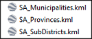
1. Incorrect spelling of KML filename or path during data import, an error message is displayed saying that the KML file cannot be located.


2. Layer ID not unique

The required KML shape is not available for selection in the Boundaries dropdown in the map formatting layout. Only the last occurrence of Layer ID = 14 (SA Provinces) will be available:

1. When adding the path to the KML file inside your plugin folder, please take note that the path and filename is case sensitive. Pay close attention to the KML filename as well and ensure that the name of the filename in the KML path in the mstrGeoShapesConfig.xml matches the filename in the KML folder in your map plugins folder. You can either rename the name of the KML file in the plugins folder, or change the name in the mstrGeoShapesConfig.xml file.

2. Ensure that each Layer ID is unique and does not match any of the other Layer IDs in the modified mstrGeoShapesConfig.xml inside the plugins folder, or the one in the parent Strategy directory (\MicroStrategy\Tomcat\apache-tomcat-9.0.50\webapps\Strategy) which contains the OOTB layers.

