EducationSoftwareStrategy.com
StrategyCommunity

Knowledge Base

Product

Community

Knowledge Base

TopicsBrowse ArticlesDeveloper Zone

Product

Download SoftwareProduct DocumentationSecurity Hub

Education

Tutorial VideosSolution GalleryEducation courses

Community

GuidelinesGrandmastersEvents
x_social-icon_white.svglinkedin_social-icon_white.svg
Strategy logoCommunity

© Strategy Inc. All Rights Reserved.

LegalTerms of UsePrivacy Policy
  1. Home
  2. Topics

KB483616: How to use affinity lines for ESRI Maps in MicroStrategy Web 9.4.1


Community Admin

• Strategy


This Knowledge Base article will walk you through steps on how to configure Affinity Lines for an ESRI Map in a 9.4.1 version of MicroStrategy Web.

To setup a ESRI Map to display affinity lines, follow these steps:
Note: The primary and secondary data providers must have the exact same attribute forms, otherwise, the affinity lines will not be displayed.
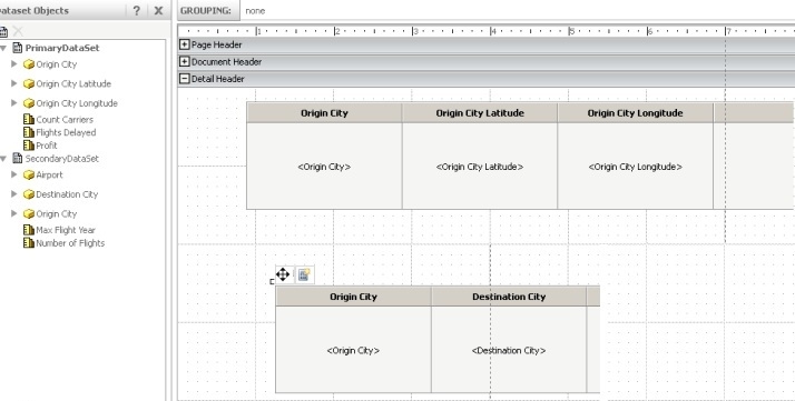
The dashboard should look like the following now: 
ka04W000001IwxhQAC_0EM4400000026j9.jpeg
ka04W000001IwxhQAC_0EM4400000026jA.jpeg


  • Create two datasets in the Report Services Document with the following characteristics:
    • Primary dataset (used to plot the markers on the map)
      • Attributes or attribute forms that supply latitude and longitude.
      • At least one metric.
      • Rows and columns that are not merged.
    • Secondary dataset (used for affinity lines)
      • The same attribute or attribute forms that supplied latitude and longitude in the primary dataset.
      • Attribute or attribute forms that supply the connecting points.
      • At least two metrics:
        • The value of the first metric is used to determine the thickness of the affinity line.
        • The value of the second metric is used to determine the color of the affinity line.
  • If the Latitude and Longitude data comes from different attributes, define the Affinity line options in the ESRI map widget properties editor as below:
ka04W000001IwxhQAC_0EM4400000026is.jpeg
  • ​​​​​​​​​​​​​​​​​​​​​​​​​​​​​​​​​​​​​​​​​​If the Latitude and Longitude data comes from different attribute forms, define the Affinity line options in the ESRI map widget properties editor as below: 
ka04W000001IwxhQAC_0EM4400000026ip.jpeg

​​​​​​​


Comment

0 comments

Details

Knowledge Article

Published:

September 16, 2019

Last Updated:

September 16, 2019