EducationSoftwareStrategy.com
StrategyCommunity

Knowledge Base

Product

Community

Knowledge Base

TopicsBrowse ArticlesDeveloper Zone

Product

Download SoftwareProduct DocumentationSecurity Hub

Education

Tutorial VideosSolution GalleryEducation courses

Community

GuidelinesGrandmastersEvents
x_social-icon_white.svglinkedin_social-icon_white.svg
Strategy logoCommunity

© Strategy Inc. All Rights Reserved.

LegalTerms of UsePrivacy Policy
  1. Home
  2. Topics

KB210826: How to determine the ESRI name conventions when plotting maps with areas in an ESRI Widget in MicroStrategy Web


Community Admin

• Strategy


Starting in MicroStrategy Web 9.4.1 plotting areas in an ESRI widget in Visual Insight Dashboards and Documents is now supported. MicroStrategy 9.4.1-10.X administrators might need to know which naming convention is being used by ESRI to populate the map layers.

Summary

Starting in Strategy Web 9.4.1 plotting areas in an ESRI widget in Visual Insight Dashboards and Documents is now supported .Strategy relies in ARCGIS map layers to source the information of the shapes that will be displayed. In order for the correct shapes to be retrieved, a query has to be made to these map layers. The query will try to make an exact match with the map layer database to retrieve the correct areas. This forces the data in the Strategy dataset to match the map layer data to work properly. Strategy 9.4.1-10.X administrators might need to know which naming convention is being used by ESRI to populate the map layers. The following steps explain how to browse the map layer information in a browser for reference of the administrators. These instructions only apply to ESRI Cloud configurations. 
 

Navigate Map Layer information in a brower

To navigate map layer information in a browser, the ARCGIS webmap viewer will be used. This map viewer is only compatible with ESRI Cloud configurations.

  • Identify the map layer that wants to be navigated. Map layers in an out of the box environment are included inside the esriConfig.xml file typically located in:
    
    C:\Program Files (x86)\Strategy\Web ASPx\WEB-INF\xml\config\esriConfig.xml


    Map Layers for a cloud configuration are included inside the <layers> section of the XML. An excerpt of this file is shown below:
    
    <layer id="1" title="US-States" ml="http://services.arcgis.com/P3ePLMYs2RVChkJx/arcgis/rest/services/USA_States_Generalized/FeatureServer/0"/>

  • Copy the URL of the Map Layer that will be navigated and save it for later use.
  • Construct the final URL with the following structure:
    map viewer URL + map layer URL
    The Map Viewer URL is: 
    
    http://www.arcgis.com/home/webmap/viewer.html?url=

    An example is shown below for the United States Map Layer:
    
    http://www.arcgis.com/home/webmap/viewer.html?url=http://services.arcgis.com/P3ePLMYs2RVChkJx/arcgis/rest/services/World_Countries_(Generalized)/FeatureServer/0
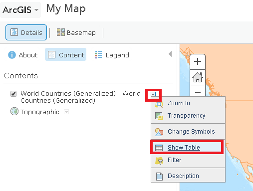

  • Once in the Map Layer manually navigate the shapes in the map layer or expose the map layer table as shown below:
ka04W00000148HpQAI_0EM4400000025vW.jpeg
  • This will show the map layer data as shown below:
ka04W00000148HpQAI_0EM4400000025vU.jpeg


KB210826


Comment

0 comments

Details

Knowledge Article

Published:

April 3, 2017

Last Updated:

November 23, 2018