SYMPTOM:
Strategy Web 9.4.1 HF5 users can configure their ESRI Map on-premise deployment to display areas based on an attribute geo-maped in the esriConfig.xml. To view more details on this procedure refer to the GIS Integration Help that corresponds to the Strategy version used.
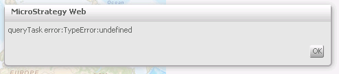
In this process, attributes can be mapped to different map layers that contain geometry information to display areas. The most commonly used geometry is esriGeometryPolygons. Strategy Administrators might configure a layer with a different type of geometries and will see the following error when executing an ESRI Map configured to display areas of type esriGeometryPoint in a DHTML document:
"queryTask error:TypeError:undefined"
In some cases the Document in Flash Mode will show the correct markers as shown below:

Note: Since this type of geometry is not supported, as it will be explained below, it is not guaranteed that it will work in Flash Mode.
CAUSE:
This is working as designed, Strategy Web 9.4.1 HF5 does not support geometries of type esriGeometryPoint. The only certified geometry type is esriGeometryPolygon. Some other types of geometries may work with the existing version of Strategy, however, these will not be supported and may not work in the future. An enhancement request has been logged to support geometries of type esriGeometryPoint.
To find the geometry type of the map layer used, access the map layer through a browser. Clicking on the link below will show an example:
http://services.arcgis.com/P3ePLMYs2RVChkJx/ArcGIS/rest/services/Customer_Information/FeatureServer/2
A field called Geometry type will contain the geometry information as shown below:

In this example, the geometry type shown above will not be supported in Strategy Web 9.4.1 HF5.
ACTION:
Contact Strategy Technical Support for an update on this enhancement request.
WORKAROUND:
Strategy Web administrators can do the following to display markers in an ESRI on-premise configuration:
KB47830
