An ESRI Map configured with the "Area" type and boundaries set to US States and Counties fails to render the shapes, like shown below.

Additionally, a login dialog may unexpectedly appear when executing the associated Dashboard which cannot be dismissed making the page of the dossier where the map is inaccessible.

Strategy utilizes ESRI APIs to fetch feature layers and render area maps. Previously, the required boundary data was publicly accessible. However, ESRI has recently updated the URLs for these resources, resulting in the failure to render ESRI maps of the "Area" type.
This change has caused some area maps to lose boundary information, leading to rendering failures. In certain cases, the map loading process encounters an access violation, which triggers the display of a log-in window.
Follow the steps to change the URL endpoint used from the deprecated one to the new one:
WebHome/WEB-INF/xml/config/esriConfig.xml
<layers>sections as shown below and modify the 2 parts highlighted in red squares.
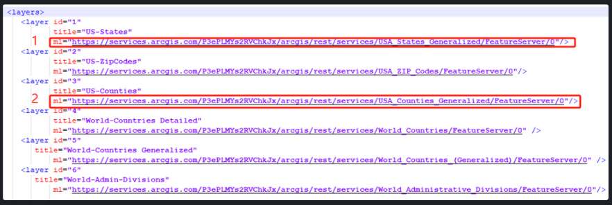
mlfield with ID=1 from:
https://services.arcgis.com/P3ePLMYs2RVChkJx/arcgis/rest/services/USA_States_Generalized/FeatureServer/0
https://services.arcgis.com/P3ePLMYs2RVChkJx/arcgis/rest/services/USA_States_Generalized_Boundaries/FeatureServer/0
ml field of with ID=3 from
https://services.arcgis.com/P3ePLMYs2RVChkJx/ArcGIS/rest/services/USA_Counties_Generalized/FeatureServer/0
to
https://services.arcgis.com/P3ePLMYs2RVChkJx/arcgis/rest/services/USA_County_Boundaries/FeatureServer/0
