EducationSoftwareStrategy.com
StrategyCommunity

Knowledge Base

Product

Community

Knowledge Base

TopicsBrowse ArticlesDeveloper Zone

Product

Download SoftwareProduct DocumentationSecurity Hub

Education

Tutorial VideosSolution GalleryEducation courses

Community

GuidelinesGrandmastersEvents
x_social-icon_white.svglinkedin_social-icon_white.svg
Strategy logoCommunity

© Strategy Inc. All Rights Reserved.

LegalTerms of UsePrivacy Policy
  1. Home
  2. Topics

KB43123: How to use affinity lines for Google Maps in MicroStrategy Web


Community Admin

• Strategy


SUMMARY:
​ This Knowledge Base article will walk you through steps on how to configure Affinity Lines in a 9.4.1 version of Strategy Web.
Before using Google Map in Strategy Web 9.3.x - 9.4.x Report Services Document, users need to fulfill the prerequisites described in KB36062.
ACTION
To setup a Google Map to display affinity lines, follow these steps:
Note: The primary and secondary data providers must have the exact same attribute forms, otherwise, the affinity lines will not be displayed
The dashboard should look like the following now: 
ka04W00000148yAQAQ_0EM4400000026j9.jpeg


ka04W00000148yAQAQ_0EM4400000026jA.jpeg
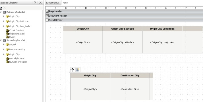
  • Create 2 datasets in the Report Services Document with the following characteristics:
    • Primary dataset (used to plot the markers on the map)
      • Attributes or attribute forms that supply latitude and longitude.
      • At least one metric.
      • Rows and columns that are not merged.
    • Secondary dataset (used for affinity lines)
      • The same attribute or attribute forms that supplied latitude and longitude in the primary dataset.
      • Attribute or attribute forms that supply the connecting points.
      • At least two metrics:
        The value of the first metric is used to determine the thickness of the affinity line.
        The value of the second metric is used to determine the color of the affinity line.
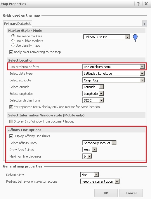
  • If the Latitude and Longitude data comes from different attributes, define the Affinity line options in the Google map widget properties editor as below:
ka04W00000148yAQAQ_0EM4400000026is.jpeg
  • Run the document: 
ka04W00000148yAQAQ_0EM4400000026j7.jpeg
  • If the Latitude and Longitude data comes from different attribute forms, define the Affinity line options in the Google map widget properties editor as below: 
ka04W00000148yAQAQ_0EM4400000026ip.jpeg
  • Run the document:
ka04W00000148yAQAQ_0EM4400000026ir.png


Comment

0 comments

Details

Knowledge Article

Published:

April 6, 2017

Last Updated:

March 30, 2018